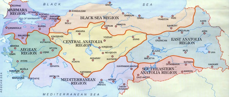
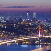
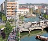
Geographically, Turkey forms a natural bridge between the old world continents of Asia, Africa and Europe. The Anatolian peninsula is the westernmost point of Asia, divided from Europe by the Bosphorus and Dardanelles straits. Thrace is the western part of Turkey on the European continent.
Examination of Turkey's topographic structure on a physical map of the world shows clearly the country's high elevation in comparison to its neighbors, half of the land area being higher than 1000 meters and two thirds higher than 800 meters. Mountain ranges extend in an east-west direction parallel to the north and south coasts, and these are a principal factor in determining ecological conditions. This also means that apart from the Asi river in Anatolia and the Meriç in Thracian Turkey, all Turkey's rivers have their sources within its borders and flow into the sea, into neighboring countries or into interior drainages. Turkey has seven river basins. The principal rivers in the Black Sea basin being the Sakarya, Kizilirmak Yesilirmak and Çoruh. There are also several rivers with short courses but high water flows in the Eastern Black Sea region, such as the Ikizdere, Hursit Cayi and Firtina. The highest waterfall in Turkey is on the Totum river here.
The Marmara basin has fewer rivers, the longest being the Kocaçay (whose upper and middle reaches are called the Simav and Susurluk respective) which rises on Mount Murat and flows into the Marmara Sea from the south.
The Kücük Menderes, Büyük Menderes and Gediz rivers in the Aegean basin lend their names to the plains which they water.
In the Mediterranean basin the principal rivers are the Aksu, Köprüçay, Manavgat, Göksu, Ceyhan and Seyhan. The Manavgat waterfall on the Manavgat, Düden waterfall on the Düden and Yerköprü waterfall on the Ermenek are among the scenic attractions of the region. The Aladag waterfall springing directly from the mountainside are one of the sources of the sources of the Seyhan river.
Two major rivers flow from Turkey into the Caspian Sea basin, the Aras and Kura.
Water from Turkey flows into the Indian Ocean through the Gulf of Basra via the famous Euphrates and Tigris rivers.
Turkey also has two inland drainage basins. The first is the Central Anatolia basin which contains the Tuz Gölü (salt lake) in Konya, and the Yay, Seyfe, Kulu and several other satellite lakes. The major river in this basin is the Çarsamba which is out flow of Beysehir Lake and contributes a large volume of water for irrigation of the fertile Konya Plain, and is linked by a canal to Tuz Gölü.
The Karasu, Incesu, Deliçay and Bendimahi rivers flow into the interior drainage basin of Van. There are waterfalls on the Bendimahi.
Another significant aspect of Turkey's topography is its continental character, preserved in the ancient name of Asia Minor. This land mass is indeed a small scale continent in many respects, above all with respect to the climate of the interior. In some provinces the temperature difference over 24 hours can be as much as 20 degrees Centigrade. During the spring months it is not unusual to find weather typical of two or even three seasons at different locations around Turkey in a single day. The Mediterranean coast may be enjoying summer heat while the temperate Black Sea region gets as much as 2000 mm of precipitation in some places, there are parts of Central Anatolia with an average precipitation only one eighth of this total.
These wide variations in temperature and precipitation affect the country's flora and fauna, both in quantity and in range of species. some parts of Turkey consist of arid highlands whereas others are thickly forested, and differences such as these play a crucial role in the distribution of wildlife around the country.
The fact that Anatolia is surrounded on there sides by sea, its situation in the temperate climatic zone, its geological and geomorphic structure, and topography are all contributing factors. The four seas around Turkey each reflect a different ecological character. Salinity is 18 per thousand in the Black Sea, 23 per thousand in the Marmara Sea, 32 per thousand in the Aegean Sea and 38 per thousand in the Mediterranean Sea. There is no other country in the world with such a wide variation of salinity levels along its shores, and the variations in ecological structure of these seas affects the life forms which inhabit them, from phyto planktons and seaweeds to fish and marine mammals such as dolphins.
Geological and topographic structure are among the main factors affecting diversity of species in terrestrial ecosystems. While the mountain ranges running parallel to the Black Sea and Mediterranean create a barrier for rain clouds moving inland, they cause abundant rainfall on the mountain slopes facing the coast. On the Aegean the mountain ranges run perpendicularly towards the coast, divided by broad valleys which allow the maritime climate to prevail several hundred kilometers inland. Alluvion carried by the rivers has created fertile plains in this Aegean region. Eastwards these mountain ranges move closer together in Central Entail, spreading apart once more in northeast and southeast Turkey. The height of plains and plateaus in Central Anatolia varies from 700 to 1100 meters, while in Eastern Anatolia this rises to 1100-19 hundred meters, and drops to 700-500 in Southeast Anatolia. Despite the existence of broad plains and plateaus, the topography is largely hilly and mountainous across Turkey as a whole.
Turkey has one peak of over 5000 meters in altitude (Mt. Ararat), three over 4000 meters and 129 peaks exceeding 3000 meters. Such an irregular topographic structure has created a wide diversity of ecological conditions and species. Now let us take a look at the geological history of the country, which has also played a part in creating the natural diversity which exists today.
Towards the end of the Quaternary Era the earth underwent four ice ages. During the cold periods when the glaciers expanded, animals seeking warmer climes moved southward into the Iberian peninsula, the Anatolian peninsula and Southeast Asia. This migration enabled these species to survive periods of glaciations. While some later returned to their former habitats, others remained in their new homelands, which explains why Turkey's wildlife today includes species of northern origin.
The distribution of flora and fauna species along a north-south axis during these glacial periods shifted to an east-west axis during temperate intervals. This further increasing the biological diversity.
The main migratory routes for birds between Asia, Europe and Africa pass over Turkey, and this has also been a factor in expanding the number of species found here for part of the year.
The combination of all these factors has resulted in a diversity of native plant animal species which is one of the highest in the world. While in terms of bio-geographic region Turkey lies in the Palaeartic zone, native species include those typical of the Oriental and Ethiopian regions. When we remember that bio-geographic regions cover vast areas, the significance of a species range drawing on there different regions can be better appreciated.
A comparable diversity can be seen in the human history of Turkey, where since prehistoric times many different peoples have settled, some to build civilizations and others to pass on to other continents. As a consequence this soil has been fought over time and time again so strategic in geopolitical terms. Over the past ten thousand years more than twenty peoples have left their mark on Turkey. Civilizations have risen and fallen in successive waves some falling victim to invasion by newcomers, some to disease epidemics, and others to natural disasters such as earthquakes.
Fresh water sources have always been a key determinant in human settlement, and where these sources have been related to tectonic faults. they have attracted settlers into areas close to earthquakes centers.
Natural resources which have benefited mankind in various ways for thousands of years have gradually been used up. Forests and their wildlife have suffered most from this process. Not only have trees been felled for timber and firewood, but set alight deliberately by ancient peoples as a means of capturing enemy towns. Even using primitive axes, people were able to destroy vast tracts of forest. Deforestation has led to serious erosion, which began around 2700 years ago. Yet despite thousands of years of destruction by logging, herds of goats, and fire, Turkey still has large tracts of beautiful natural forest land.
Sources: http://www.allaboutturkey.com/

